![](/images/other/stat-length.png)
![Excursión Bici de montaña La Motte-en-Champsaur - piste du roy - Photo](https://media.geolcdn.com/t/1900/400/ext.pjpeg?maxdim=2&url=https%3A%2F%2Fstatic1.geolcdn.com%2Fsiteimages%2Fupload%2Ffiles%2F1524743154velo.jpg)
piste du roy
charlottedigne
Usuario
![Longitud](/images/other/stat-length.png)
Longitud
8 km
![Altitud máxima](https://static1.geolcdn.com/siteimages/upload/files/1508320355ic_sort_altitude_max_24dp.png)
Altitud máxima
1406 m
![Desnivel positivo](https://static1.geolcdn.com/siteimages/upload/files/1508320355ic_sort_den_pos_24dp.png)
Desnivel positivo
182 m
![Km-Effort](/images/other/stat-length.png)
Km-Effort
10,4 km
![Altitud mínima](https://static1.geolcdn.com/siteimages/upload/files/1508320355ic_sort_altitude_min_24dp.png)
Altitud mínima
1244 m
![Desnivel negativo](https://static1.geolcdn.com/siteimages/upload/files/1508320355ic_sort_den_neg_24dp.png)
Desnivel negativo
182 m
![Boucle](https://static1.geolcdn.com/siteimages/upload/files/16400158638029165_repeat_loop_refresh_sync_direction_icon.png)
Boucle
Sí
Fecha de creación :
2024-08-03 08:49:21.186
Última modificación :
2024-08-03 12:08:57.904
![Bici de montaña](https://static1.geolcdn.com/sitytour/trail-icons/202.png)
2h22
Dificultad : Fácil
![Escanee este código QR para abrir la excursión en la aplicación SityTrail](https://capi.geolives.com/qq0zvz2zws4bq2lad0pu/sitytour/trails/4142912/qr.png?size=200)
Aplicación GPS de excursión GRATIS
A propósito
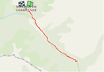
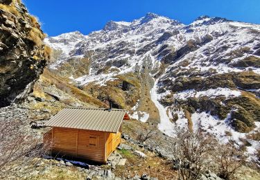
Ruta Bici de montaña de 8 km a descubrir en Provenza-Alpes-Costa Azul, Altos Alpes, La Motte-en-Champsaur. Esta ruta ha sido propuesta por charlottedigne.
Descripción
en VTT avec des enfants, très roulant à la descente, plus ardu à la montée.
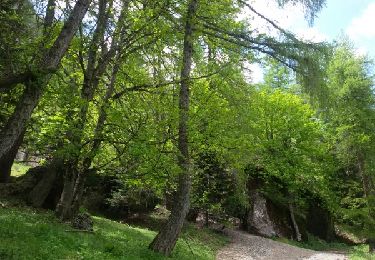
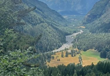
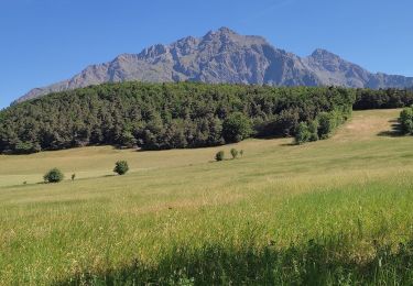
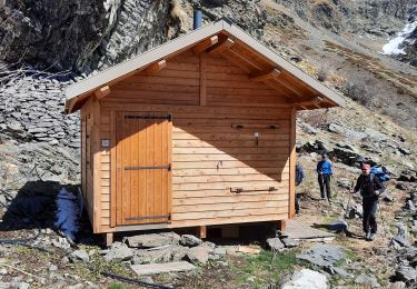
Localización
País:
France
Región :
Provenza-Alpes-Costa Azul
Departamento/provincia :
Altos Alpes
Municipio :
La Motte-en-Champsaur
Localidad:
Unknown
Salida:(Dec)
Salida:(UTM)
272236 ; 4958850 (32T) N.
Comentarios
Excursiones cerca
![Excursión Senderismo Saint-Bonnet-en-Champsaur - Les infournas - Lac des Barbeyroux 22/09/23 - Photo](https://media.geolcdn.com/t/375/260/0538c280-feb5-4d65-96e8-19b0b69c47f0.jpg&format=jpg&maxdim=2)
![Senderismo Senderismo](https://static1.geolcdn.com/sitytour/trail-icons/101.png)
Les infournas - Lac des Barbeyroux 22/09/23
Senderismo
Difícil
Saint-Bonnet-en-Champsaur,
Provenza-Alpes-Costa Azul,
Altos Alpes,
France
![](/images/other/stat-length.png)
10,1 km | 16 km-effort
3h 38min
![](https://static1.geolcdn.com/siteimages/upload/files/16400158638029165_repeat_loop_refresh_sync_direction_icon.png)
Sí
![Excursión Senderismo La Motte-en-Champsaur - Jas de Jartier - Photo](https://media.geolcdn.com/t/375/260/f77a6a7c-6e5d-40aa-9152-87e370bb16b8.jpg&format=jpg&maxdim=2)
![Senderismo Senderismo](https://static1.geolcdn.com/sitytour/trail-icons/101.png)
Jas de Jartier
Senderismo
Difícil
La Motte-en-Champsaur,
Provenza-Alpes-Costa Azul,
Altos Alpes,
France
![](/images/other/stat-length.png)
13,7 km | 24 km-effort
5h 22min
![](https://static1.geolcdn.com/siteimages/upload/files/16400158638029165_repeat_loop_refresh_sync_direction_icon.png)
Sí
![Excursión Senderismo Saint-Bonnet-en-Champsaur - Col de l'Escalier - Photo](https://media.geolcdn.com/t/375/260/380e390b-b1b8-4ba8-8042-65c036c6fc44.jpg&format=jpg&maxdim=2)
![Senderismo Senderismo](https://static1.geolcdn.com/sitytour/trail-icons/101.png)
Col de l'Escalier
Senderismo
Medio
Saint-Bonnet-en-Champsaur,
Provenza-Alpes-Costa Azul,
Altos Alpes,
France
![](/images/other/stat-length.png)
19,6 km | 33 km-effort
6h 3min
![](https://static1.geolcdn.com/siteimages/upload/files/16400158638029165_repeat_loop_refresh_sync_direction_icon.png)
Sí
![Excursión Senderismo Saint-Jacques-en-Valgodemard - 20190409_Lac de Roaffan - Photo](https://media.geolcdn.com/t/375/260/9022de43-54f4-44a8-9678-8541607672ee.jpg&format=jpg&maxdim=2)
![Senderismo Senderismo](https://static1.geolcdn.com/sitytour/trail-icons/101.png)
20190409_Lac de Roaffan
Senderismo
Fácil
Saint-Jacques-en-Valgodemard,
Provenza-Alpes-Costa Azul,
Altos Alpes,
France
![](/images/other/stat-length.png)
12,3 km | 18 km-effort
5h 47min
![](https://static1.geolcdn.com/siteimages/upload/files/16400158638029165_repeat_loop_refresh_sync_direction_icon.png)
Sí
![Excursión Senderismo La Motte-en-Champsaur - 01-06-14 Chemin de Ronde de Molines - Photo](https://media.geolcdn.com/t/375/260/ext.jpg?maxdim=2&url=https%3A%2F%2Fservices.sitytrail.com%2FGeolivesWS%2FDownloadMedia.ashx%3FTrailID%3D308305%26Media%3Dfix__20140601142415.jpg)
![Senderismo Senderismo](https://static1.geolcdn.com/sitytour/trail-icons/101.png)
01-06-14 Chemin de Ronde de Molines
Senderismo
Medio
La Motte-en-Champsaur,
Provenza-Alpes-Costa Azul,
Altos Alpes,
France
![](/images/other/stat-length.png)
17,5 km | 31 km-effort
6h 22min
![](https://static1.geolcdn.com/siteimages/upload/files/16400158638029165_repeat_loop_refresh_sync_direction_icon.png)
No
![Excursión Senderismo La Motte-en-Champsaur - 2023 Molines en champsaur - Photo](https://media.geolcdn.com/t/375/260/8cec2c36-77a4-44ec-9429-880c71e3680f.jpg&format=jpg&maxdim=2)
![Senderismo Senderismo](https://static1.geolcdn.com/sitytour/trail-icons/101.png)
2023 Molines en champsaur
Senderismo
Muy difícil
La Motte-en-Champsaur,
Provenza-Alpes-Costa Azul,
Altos Alpes,
France
![](/images/other/stat-length.png)
12,2 km | 19,3 km-effort
4h 0min
![](https://static1.geolcdn.com/siteimages/upload/files/16400158638029165_repeat_loop_refresh_sync_direction_icon.png)
No
![Excursión Senderismo La Motte-en-Champsaur - La Motte le Col de la Blache - Photo](https://media.geolcdn.com/t/375/260/b61f57f6-a4e9-410d-9b38-3ccb5733b4a6.jpg&format=jpg&maxdim=2)
![Senderismo Senderismo](https://static1.geolcdn.com/sitytour/trail-icons/101.png)
La Motte le Col de la Blache
Senderismo
Medio
La Motte-en-Champsaur,
Provenza-Alpes-Costa Azul,
Altos Alpes,
France
![](/images/other/stat-length.png)
12,8 km | 19,3 km-effort
4h 8min
![](https://static1.geolcdn.com/siteimages/upload/files/16400158638029165_repeat_loop_refresh_sync_direction_icon.png)
Sí
![Excursión Senderismo La Motte-en-Champsaur - jas de jartier - Photo](https://media.geolcdn.com/t/375/260/3c33cb52-561b-40aa-8cdd-d79fd690218e.jpg&format=jpg&maxdim=2)
![Senderismo Senderismo](https://static1.geolcdn.com/sitytour/trail-icons/101.png)
jas de jartier
Senderismo
Medio
La Motte-en-Champsaur,
Provenza-Alpes-Costa Azul,
Altos Alpes,
France
![](/images/other/stat-length.png)
12,8 km | 23 km-effort
5h 25min
![](https://static1.geolcdn.com/siteimages/upload/files/16400158638029165_repeat_loop_refresh_sync_direction_icon.png)
Sí
![Excursión Senderismo La Motte-en-Champsaur - Jas de Jartier - Photo](https://media.geolcdn.com/t/375/260/51d99883-619f-4da2-9c23-416dc15ef668.jpg&format=jpg&maxdim=2)
![Senderismo Senderismo](https://static1.geolcdn.com/sitytour/trail-icons/101.png)
Jas de Jartier
Senderismo
Muy difícil
La Motte-en-Champsaur,
Provenza-Alpes-Costa Azul,
Altos Alpes,
France
![](/images/other/stat-length.png)
13,6 km | 24 km-effort
5h 30min
![](https://static1.geolcdn.com/siteimages/upload/files/16400158638029165_repeat_loop_refresh_sync_direction_icon.png)
Sí